Government
Departments & Services
Doing Business
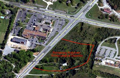
The ruins of an incredible historic find, a Native American village dating from the mid-1400s, lie just across Old Hickory Boulevard from Forest Hills City Hall. It is the largest late-prehistoric town remaining in Davidson County, and one of the few intact towns of its era in the region.
A Friends group raised $400,000 to help Metro buy, maintain, and develop the property. The contribution included $100,000 from the City of Forest Hills. The Board of Commissioners advocated that the site be protected from commercial development and preserved as open space. In 2014 Metro Nashville purchased the property, which will be a Metro park.
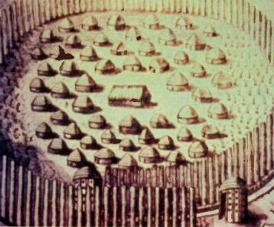
The village was surrounded by a palisade.
Gary Barker, the TDOT archaeologist who first discovered the remains of the Mississippian village in 1999, named the site in honor of Mrs. Elizabeth Douglass Levine Kelly, who owned the property at the time.
While the board of directors of the Friends of Kellytown respects the great contributions of Gary Barker and Mrs. Kelly, it determined that the site needed to have a Native American name. The master plan calls for the park site to be used to educate the public about the importance of the lost history of the Mississippian people who lived on this site before the arrival of Europeans in America.
Forest Hills resident Mark McNeely with McNeely Pigott & Fox Public Relations conducted a survey to determine the public’s reaction to a Native American name. The results showed that a name change would be a positive move, with nine out of ten respondents agreeing that a name that better reflects the park’s Native American heritage is appropriate.
Mike Moore, the Tennessee state archaeologist, contacted the Chickasaw Nation in search of a Muskogean language name for the site. Experts suggested aaittafama’ which translates to “a place for meeting together” in the Chickasaw/Muskogean language.
Metro Parks approved this name change at its February meeting. The new name is now officially Aaittafama’ Archaeological Park, and the Friends group is the Friends of Aaittafama’ Park.
Aaittafama’
(ah-IT-tah-fah-mah)
A place for meeting together.
– Chickasaw/ Muskogean
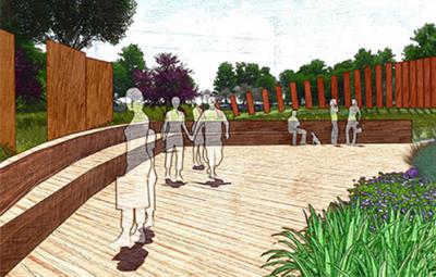
The Master Plan for Aaittafama’ has as a visual focal point a large art feature of the palisade wall and a video/3D presentation that would enable the visitor to see the site as it might have looked at the time the Mississippian people lived there.
There will also be a pavilion for school groups and other visitors to learn about the Mississippian culture.
Another feature will be an agricultural display garden where specimens of crops grown in the Mississippian era will be on display.
Walking trails will lead the visitor to the points of interest in the park as well as connecting with proposed Brentwood Greenways in the future. The area closest to Old Hickory Boulevard will be reserved for parking.
The Master Plan was authorized and funded by the Friends of Aaittafama'.
Features
Event Lawn (Plaza Interpretation)
Informational Mississippian Culture Plaza
Vehicular Parking
Rain Garden
Native Vegetation
Historic Palisade Line
Interpretive Palisade Line
Bus Parking
Gateway / Signage
Connection to Proposed Greenway
Agricultural Display Gardens
Migratory Sculpture
Bio-Swale
Interpretive Plaza
Historic Kelly House
Existing House
Vegetative Screening
Educational Plaza
Historic Kelly Cemetery
The discovery of Aaittafama’ came about as a result of a proposal by Tennessee Department of Transportation to build a turn lane onto Old Hickory Boulevard for northbound traffic on Hillsboro Pike. State archeologists reported that historic graves from the Mississippian Period (about A.D. 900 to 1500) might be present, and required more extensive investigation before construction could begin.
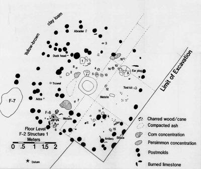
The results were astounding. In just 30 feet of right-of-way along Hillsboro Pike, TDOT’s exploration in 1999 found evidence of the following:
Twelve structures.
Seven human graves.
Two palisade lines with bastions.
Wattle and daub walls.
Remnants of food including corn and nuts.
Domestic artifacts such as frog-shaped bowls and other vessels.
The presence and distribution of the palisades, structures, and other items provide explicit proof that intact archaeological features are present underground, state archeologist Michael Moore said. This part of Middle Tennessee was heavily populated in villages during the Mississippian Period, centuries before Europeans began exploring the region, making it potentially rich in archeological resources, but evidence of almost all these villages has been lost to commercial and housing development.
What was life like in Aaittafama’? The town was well established, with probably sixty or so families who had been there for decades. They hunt, fish, and farm the land, living in homes built of wattle-and-daub. They created community buildings for storing food and supplies, and constructed palisade fortifications to keep their livestock in and intruders or wild animals out.
No one may ever know definitively what happened, but something traumatic occurred around 1450 that caused the villagers to leave suddenly. Maybe a fire burned out of control, or hostile invaders attacked. For whatever reason, the townspeople quickly evacuated, leaving behind their homes, cooking utensils, possessions, all they had.